|
|
|||||||||||||||||
| Point ID: 7795 | Downloads | Plots | Site Data | Code: 3070 |
|
|
|||||||||||||||||
| Download | |
|---|---|
| Site Descriptor Information | Site Time Series Data |
| Link to all available data | |
| View: | Time Series | All |
| Units: | mm |
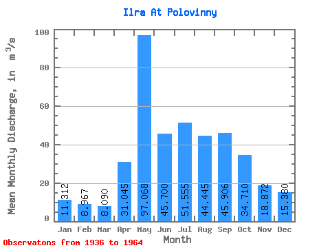
| Statistic | Jan | Feb | Mar | Apr | May | Jun | Jul | Aug | Sep | Oct | Nov | Dec | Annual |
|---|---|---|---|---|---|---|---|---|---|---|---|---|---|
| Mean | 11.31 | 8.97 | 8.09 | 31.05 | 97.07 | 45.70 | 51.55 | 44.45 | 45.91 | 34.71 | 18.87 | 15.38 | 34.32 |
| Standard Deviation | 6.25 | 4.80 | 4.44 | 28.02 | 46.44 | 33.71 | 38.30 | 28.78 | 31.88 | 19.35 | 9.76 | 8.33 | 14.27 |
| Min | 1.58 | 1.39 | 0.96 | 4.42 | 22.10 | 19.30 | 10.50 | 12.30 | 9.74 | 8.63 | 4.26 | 3.40 | 13.73 |
| Max | 24.40 | 17.60 | 15.80 | 101.00 | 186.00 | 166.00 | 144.00 | 133.00 | 120.00 | 73.60 | 35.10 | 32.40 | 68.32 |
| Coefficient of Variation | 0.55 | 0.54 | 0.55 | 0.90 | 0.48 | 0.74 | 0.74 | 0.65 | 0.69 | 0.56 | 0.52 | 0.54 | 0.42 |
 Return to R-Arctic Net Home Page