|
|
|||||||||||||||||
| Point ID: 7773 | Downloads | Plots | Site Data | Code: 10HA004 |
|
|
|||||||||||||||||
| Download | |
|---|---|
| Site Descriptor Information | Site Time Series Data |
| Link to all available data | |
| View: | Time Series | All |
| Units: | m3/s |
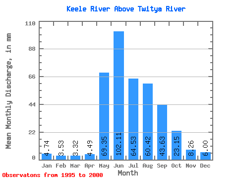
| Statistic | Jan | Feb | Mar | Apr | May | Jun | Jul | Aug | Sep | Oct | Nov | Dec | Annual |
|---|---|---|---|---|---|---|---|---|---|---|---|---|---|
| Mean | 4.73 | 3.56 | 3.32 | 4.49 | 69.34 | 102.11 | 64.52 | 60.41 | 43.63 | 23.15 | 8.26 | 6.00 | 324.64 |
| Standard Deviation | 0.37 | 0.69 | 1.08 | 35.34 | 16.59 | 16.83 | 11.41 | ||||||
| Min | 4.47 | 3.07 | 2.56 | 4.49 | 69.34 | 61.33 | 40.41 | 35.87 | 22.47 | 23.15 | 8.26 | 6.00 | 324.64 |
| Max | 5.00 | 4.05 | 4.09 | 4.49 | 69.34 | 158.99 | 84.41 | 74.84 | 52.77 | 23.15 | 8.26 | 6.00 | 324.64 |
| Coefficient of Variation | 0.08 | 0.20 | 0.33 | 0.35 | 0.26 | 0.28 | 0.26 |
 Return to R-Arctic Net Home Page