|
|
|||||||||||||||||
| Point ID: 7773 | Downloads | Plots | Site Data | Code: 10HA004 |
|
|
|||||||||||||||||
| Download | |
|---|---|
| Site Descriptor Information | Site Time Series Data |
| Link to all available data | |
| View: | Time Series | All |
| Units: | mm |
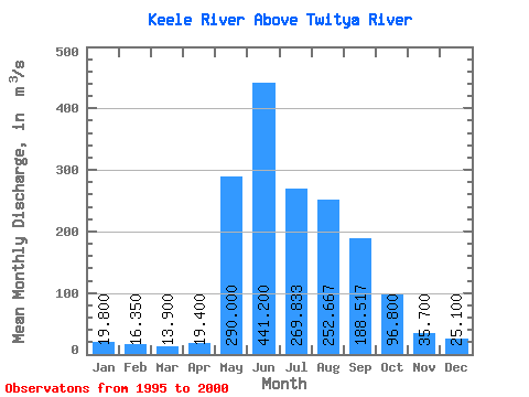
| Statistic | Jan | Feb | Mar | Apr | May | Jun | Jul | Aug | Sep | Oct | Nov | Dec | Annual |
|---|---|---|---|---|---|---|---|---|---|---|---|---|---|
| Mean | 19.80 | 16.35 | 13.90 | 19.40 | 290.00 | 441.20 | 269.83 | 252.67 | 188.52 | 96.80 | 35.70 | 25.10 | 115.21 |
| Standard Deviation | 1.56 | 3.18 | 4.53 | 152.68 | 69.40 | 70.38 | 49.29 | ||||||
| Min | 18.70 | 14.10 | 10.70 | 19.40 | 290.00 | 265.00 | 169.00 | 150.00 | 97.10 | 96.80 | 35.70 | 25.10 | 115.21 |
| Max | 20.90 | 18.60 | 17.10 | 19.40 | 290.00 | 687.00 | 353.00 | 313.00 | 228.00 | 96.80 | 35.70 | 25.10 | 115.21 |
| Coefficient of Variation | 0.08 | 0.20 | 0.33 | 0.35 | 0.26 | 0.28 | 0.26 |
 Return to R-Arctic Net Home Page