|
|
|||||||||||||||||
| Point ID: 773 | Downloads | Plots | Site Data | Code: 07GJ001 |
|
|
|||||||||||||||||
| Download | |
|---|---|
| Site Descriptor Information | Site Time Series Data |
| Link to all available data | |
| View: | Time Series | All |
| Units: | m3/s |
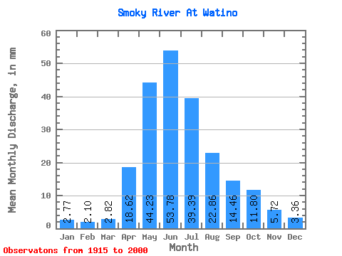
| Statistic | Jan | Feb | Mar | Apr | May | Jun | Jul | Aug | Sep | Oct | Nov | Dec | Annual |
|---|---|---|---|---|---|---|---|---|---|---|---|---|---|
| Mean | 2.73 | 2.09 | 2.78 | 18.36 | 43.61 | 53.03 | 38.83 | 22.54 | 14.26 | 11.63 | 5.64 | 3.31 | 218.02 |
| Standard Deviation | 1.16 | 0.61 | 1.66 | 10.56 | 17.83 | 18.80 | 17.18 | 13.54 | 6.87 | 5.28 | 2.28 | 1.15 | 56.09 |
| Min | 1.22 | 1.08 | 1.17 | 4.11 | 15.39 | 21.90 | 13.84 | 8.62 | 5.51 | 4.30 | 2.25 | 1.31 | 117.11 |
| Max | 8.41 | 4.07 | 12.56 | 46.38 | 100.62 | 106.67 | 88.38 | 63.89 | 33.65 | 25.29 | 15.72 | 7.56 | 366.90 |
| Coefficient of Variation | 0.43 | 0.29 | 0.60 | 0.57 | 0.41 | 0.35 | 0.44 | 0.60 | 0.48 | 0.45 | 0.40 | 0.35 | 0.26 |
 Return to R-Arctic Net Home Page