|
|
|||||||||||||||||
| Point ID: 773 | Downloads | Plots | Site Data | Code: 07GJ001 |
|
|
|||||||||||||||||
| Download | |
|---|---|
| Site Descriptor Information | Site Time Series Data |
| Link to all available data | |
| View: | Time Series | All |
| Units: | mm |
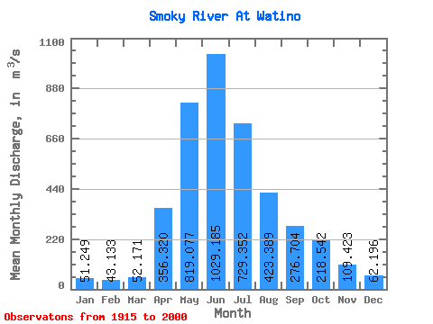
| Statistic | Jan | Feb | Mar | Apr | May | Jun | Jul | Aug | Sep | Oct | Nov | Dec | Annual |
|---|---|---|---|---|---|---|---|---|---|---|---|---|---|
| Mean | 51.25 | 43.13 | 52.17 | 356.32 | 819.08 | 1029.18 | 729.35 | 423.39 | 276.70 | 218.54 | 109.42 | 62.20 | 347.48 |
| Standard Deviation | 21.85 | 12.60 | 31.20 | 204.90 | 334.91 | 364.93 | 322.62 | 254.33 | 133.32 | 99.16 | 44.19 | 21.68 | 89.40 |
| Min | 22.90 | 22.20 | 21.90 | 79.80 | 289.00 | 425.00 | 260.00 | 162.00 | 107.00 | 80.70 | 43.60 | 24.70 | 186.64 |
| Max | 158.00 | 83.80 | 236.00 | 900.00 | 1890.00 | 2070.00 | 1660.00 | 1200.00 | 653.00 | 475.00 | 305.00 | 142.00 | 584.76 |
| Coefficient of Variation | 0.43 | 0.29 | 0.60 | 0.57 | 0.41 | 0.35 | 0.44 | 0.60 | 0.48 | 0.45 | 0.40 | 0.35 | 0.26 |
 Return to R-Arctic Net Home Page