|
|
|||||||||||||||||
| Point ID: 769 | Downloads | Plots | Site Data | Other Close Sites | Code: 07GH002 |
|
|
|||||||||||||||||
| Download | |
|---|---|
| Site Descriptor Information | Site Time Series Data |
| Link to all available data | |
| View: | Time Series | All |
| Units: | m3/s |
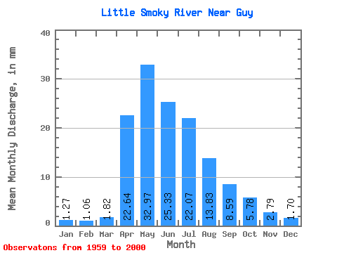
| Statistic | Jan | Feb | Mar | Apr | May | Jun | Jul | Aug | Sep | Oct | Nov | Dec | Annual |
|---|---|---|---|---|---|---|---|---|---|---|---|---|---|
| Mean | 1.27 | 1.07 | 1.82 | 22.64 | 32.97 | 25.33 | 22.07 | 13.83 | 8.59 | 5.78 | 2.79 | 1.70 | 137.40 |
| Standard Deviation | 0.55 | 0.41 | 1.23 | 17.43 | 20.45 | 19.79 | 19.04 | 15.39 | 7.42 | 4.45 | 1.60 | 0.88 | 59.66 |
| Min | 0.33 | 0.36 | 0.71 | 2.57 | 6.13 | 4.18 | 3.02 | 2.26 | 1.06 | 1.30 | 0.42 | 0.31 | 46.15 |
| Max | 2.75 | 2.04 | 8.28 | 72.39 | 85.65 | 113.02 | 83.72 | 80.58 | 26.62 | 19.28 | 7.43 | 3.76 | 274.75 |
| Coefficient of Variation | 0.43 | 0.39 | 0.68 | 0.77 | 0.62 | 0.78 | 0.86 | 1.11 | 0.86 | 0.77 | 0.57 | 0.52 | 0.43 |
| Other Close Sites | ||||||
|---|---|---|---|---|---|---|
| PointID | Latitude | Longitude | Drainage Area | Source | Name | |
| 768 | "LITTLE SMOKY RIVER NEAR TRIANGLE" | 55.37 | 1717026 | Hydat | ||
 Return to R-Arctic Net Home Page