|
|
|||||||||||||||||
| Point ID: 769 | Downloads | Plots | Site Data | Other Close Sites | Code: 07GH002 |
|
|
|||||||||||||||||
| Download | |
|---|---|
| Site Descriptor Information | Site Time Series Data |
| Link to all available data | |
| View: | Time Series | All |
| Units: | mm |
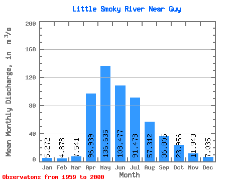
| Statistic | Jan | Feb | Mar | Apr | May | Jun | Jul | Aug | Sep | Oct | Nov | Dec | Annual |
|---|---|---|---|---|---|---|---|---|---|---|---|---|---|
| Mean | 5.27 | 4.88 | 7.54 | 96.94 | 136.63 | 108.48 | 91.48 | 57.31 | 36.80 | 23.96 | 11.94 | 7.04 | 48.33 |
| Standard Deviation | 2.29 | 1.88 | 5.09 | 74.64 | 84.75 | 84.74 | 78.93 | 63.80 | 31.77 | 18.44 | 6.87 | 3.64 | 20.98 |
| Min | 1.38 | 1.62 | 2.94 | 11.00 | 25.40 | 17.90 | 12.50 | 9.38 | 4.55 | 5.40 | 1.82 | 1.30 | 16.23 |
| Max | 11.40 | 9.30 | 34.30 | 310.00 | 355.00 | 484.00 | 347.00 | 334.00 | 114.00 | 79.90 | 31.80 | 15.60 | 96.63 |
| Coefficient of Variation | 0.43 | 0.39 | 0.68 | 0.77 | 0.62 | 0.78 | 0.86 | 1.11 | 0.86 | 0.77 | 0.57 | 0.52 | 0.43 |
| Other Close Sites | ||||||
|---|---|---|---|---|---|---|
| PointID | Latitude | Longitude | Drainage Area | Source | Name | |
| 768 | "LITTLE SMOKY RIVER NEAR TRIANGLE" | 55.37 | 1717026 | Hydat | ||
 Return to R-Arctic Net Home Page