|
|
|||||||||||||||||
| Point ID: 7689 | Downloads | Plots | Site Data | Code: 15746000 |
|
|
|||||||||||||||||
| Download | |
|---|---|
| Site Descriptor Information | Site Time Series Data |
| Link to all available data | |
| View: | Time Series | All |
| Units: | m3/s |
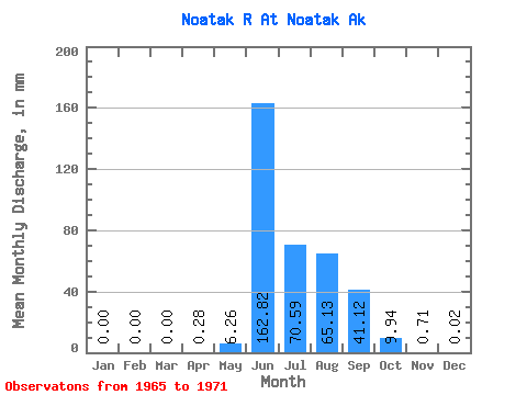
| Statistic | Jan | Feb | Mar | Apr | May | Jun | Jul | Aug | Sep | Oct | Nov | Dec | Annual |
|---|---|---|---|---|---|---|---|---|---|---|---|---|---|
| Mean | 0.00 | 0.00 | 0.00 | 0.28 | 6.26 | 162.82 | 70.58 | 65.12 | 41.12 | 9.94 | 0.71 | 0.02 | |
| Standard Deviation | 1.63 | 84.44 | 34.39 | 51.83 | 41.98 | 8.14 | |||||||
| Min | 0.00 | 0.00 | 0.00 | 0.28 | 4.86 | 40.67 | 22.90 | 21.50 | 13.53 | 0.73 | 0.71 | 0.02 | |
| Max | 0.00 | 0.00 | 0.00 | 0.28 | 8.05 | 266.23 | 120.78 | 164.74 | 133.42 | 23.53 | 0.71 | 0.02 | |
| Coefficient of Variation | 0.26 | 0.52 | 0.49 | 0.80 | 1.02 | 0.82 |
 Return to R-Arctic Net Home Page