|
|
|||||||||||||||||
| Point ID: 7689 | Downloads | Plots | Site Data | Code: 15746000 |
|
|
|||||||||||||||||
| Download | |
|---|---|
| Site Descriptor Information | Site Time Series Data |
| Link to all available data | |
| View: | Time Series | All |
| Units: | mm |
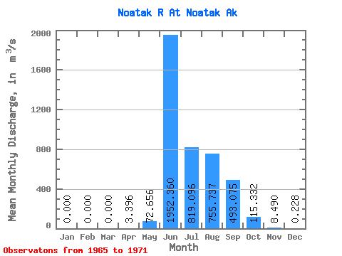
| Statistic | Jan | Feb | Mar | Apr | May | Jun | Jul | Aug | Sep | Oct | Nov | Dec | Annual |
|---|---|---|---|---|---|---|---|---|---|---|---|---|---|
| Mean | 0.00 | 0.00 | 0.00 | 3.40 | 72.66 | 1952.36 | 819.10 | 755.74 | 493.07 | 115.33 | 8.49 | 0.23 | |
| Standard Deviation | 18.89 | 1012.49 | 399.08 | 601.54 | 503.37 | 94.48 | |||||||
| Min | 0.00 | 0.00 | 0.00 | 3.40 | 56.43 | 487.61 | 265.74 | 249.52 | 162.22 | 8.52 | 8.49 | 0.23 | |
| Max | 0.00 | 0.00 | 0.00 | 3.40 | 93.39 | 3192.24 | 1401.70 | 1911.95 | 1599.80 | 273.04 | 8.49 | 0.23 | |
| Coefficient of Variation | 0.26 | 0.52 | 0.49 | 0.80 | 1.02 | 0.82 |
 Return to R-Arctic Net Home Page