|
|
|||||||||||||||||
| Point ID: 766 | Downloads | Plots | Site Data | Code: 07GG002 |
|
|
|||||||||||||||||
| Download | |
|---|---|
| Site Descriptor Information | Site Time Series Data |
| Link to all available data | |
| View: | Time Series | All |
| Units: | m3/s |
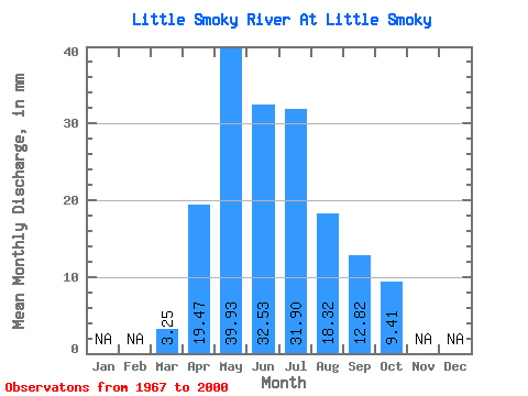
| Statistic | Jan | Feb | Mar | Apr | May | Jun | Jul | Aug | Sep | Oct | Nov | Dec | Annual |
|---|---|---|---|---|---|---|---|---|---|---|---|---|---|
| Mean | 3.25 | 19.47 | 39.92 | 32.53 | 31.90 | 18.31 | 12.82 | 9.41 | |||||
| Standard Deviation | 1.75 | 11.34 | 23.75 | 22.91 | 28.13 | 15.72 | 11.13 | 6.42 | |||||
| Min | 1.36 | 3.70 | 6.73 | 6.48 | 3.70 | 3.70 | 2.04 | 2.77 | |||||
| Max | 11.83 | 50.29 | 101.43 | 99.03 | 104.09 | 59.97 | 52.44 | 26.07 | |||||
| Coefficient of Variation | 0.54 | 0.58 | 0.59 | 0.70 | 0.88 | 0.86 | 0.87 | 0.68 |
 Return to R-Arctic Net Home Page