|
|
|||||||||||||||||
| Point ID: 766 | Downloads | Plots | Site Data | Code: 07GG002 |
|
|
|||||||||||||||||
| Download | |
|---|---|
| Site Descriptor Information | Site Time Series Data |
| Link to all available data | |
| View: | Time Series | All |
| Units: | mm |
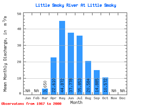
| Statistic | Jan | Feb | Mar | Apr | May | Jun | Jul | Aug | Sep | Oct | Nov | Dec | Annual |
|---|---|---|---|---|---|---|---|---|---|---|---|---|---|
| Mean | 3.65 | 22.61 | 44.87 | 37.78 | 35.85 | 20.58 | 14.88 | 10.57 | |||||
| Standard Deviation | 1.97 | 13.17 | 26.70 | 26.61 | 31.62 | 17.67 | 12.93 | 7.21 | |||||
| Min | 1.53 | 4.30 | 7.56 | 7.53 | 4.16 | 4.16 | 2.37 | 3.11 | |||||
| Max | 13.30 | 58.40 | 114.00 | 115.00 | 117.00 | 67.40 | 60.90 | 29.30 | |||||
| Coefficient of Variation | 0.54 | 0.58 | 0.59 | 0.70 | 0.88 | 0.86 | 0.87 | 0.68 |
 Return to R-Arctic Net Home Page