|
|
|||||||||||||||||
| Point ID: 7639 | Downloads | Plots | Site Data | Code: 71186 |
|
|
|||||||||||||||||
| Download | |
|---|---|
| Site Descriptor Information | Site Time Series Data |
| Link to all available data | |
| View: | Time Series | All |
| Units: | m3/s |
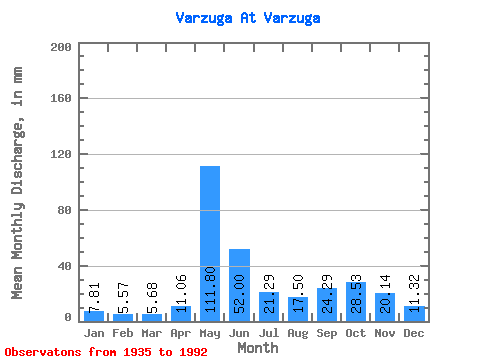
| Statistic | Jan | Feb | Mar | Apr | May | Jun | Jul | Aug | Sep | Oct | Nov | Dec | Annual |
|---|---|---|---|---|---|---|---|---|---|---|---|---|---|
| Mean | 7.81 | 5.62 | 5.67 | 11.06 | 111.78 | 52.00 | 21.28 | 17.50 | 24.29 | 28.53 | 20.14 | 11.32 | 315.07 |
| Standard Deviation | 2.27 | 1.36 | 1.60 | 11.03 | 42.78 | 27.19 | 10.89 | 9.95 | 13.07 | 13.66 | 11.59 | 4.55 | 67.56 |
| Min | 2.76 | 2.31 | 3.05 | 3.62 | 26.38 | 13.68 | 6.41 | 5.13 | 6.37 | 5.23 | 3.82 | 3.68 | 133.52 |
| Max | 15.38 | 10.36 | 12.68 | 58.76 | 210.46 | 132.21 | 57.34 | 64.42 | 69.86 | 66.44 | 51.91 | 23.17 | 508.98 |
| Coefficient of Variation | 0.29 | 0.24 | 0.28 | 1.00 | 0.38 | 0.52 | 0.51 | 0.57 | 0.54 | 0.48 | 0.58 | 0.40 | 0.21 |
 Return to R-Arctic Net Home Page