|
|
|||||||||||||||||
| Point ID: 7639 | Downloads | Plots | Site Data | Code: 71186 |
|
|
|||||||||||||||||
| Download | |
|---|---|
| Site Descriptor Information | Site Time Series Data |
| Link to all available data | |
| View: | Time Series | All |
| Units: | mm |
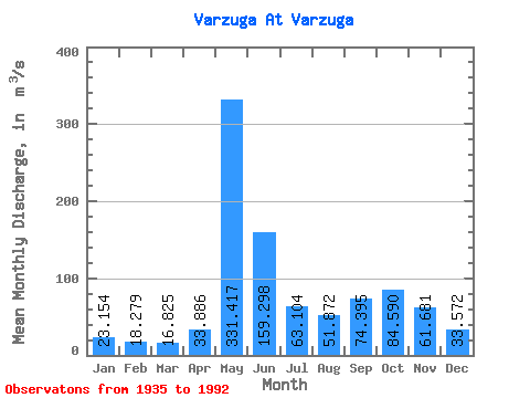
| Statistic | Jan | Feb | Mar | Apr | May | Jun | Jul | Aug | Sep | Oct | Nov | Dec | Annual |
|---|---|---|---|---|---|---|---|---|---|---|---|---|---|
| Mean | 23.15 | 18.28 | 16.82 | 33.89 | 331.42 | 159.30 | 63.10 | 51.87 | 74.39 | 84.59 | 61.68 | 33.57 | 79.27 |
| Standard Deviation | 6.72 | 4.43 | 4.75 | 33.79 | 126.83 | 83.29 | 32.29 | 29.50 | 40.04 | 40.50 | 35.51 | 13.49 | 17.00 |
| Min | 8.17 | 7.51 | 9.04 | 11.10 | 78.20 | 41.90 | 19.00 | 15.20 | 19.50 | 15.50 | 11.70 | 10.90 | 33.59 |
| Max | 45.60 | 33.70 | 37.60 | 180.00 | 624.00 | 405.00 | 170.00 | 191.00 | 214.00 | 197.00 | 159.00 | 68.70 | 128.05 |
| Coefficient of Variation | 0.29 | 0.24 | 0.28 | 1.00 | 0.38 | 0.52 | 0.51 | 0.57 | 0.54 | 0.48 | 0.58 | 0.40 | 0.21 |
 Return to R-Arctic Net Home Page