|
|
|||||||||||||||||
| Point ID: 7634 | Downloads | Plots | Site Data | Code: 71177 |
|
|
|||||||||||||||||
| Download | |
|---|---|
| Site Descriptor Information | Site Time Series Data |
| Link to all available data | |
| View: | Time Series | All |
| Units: | m3/s |
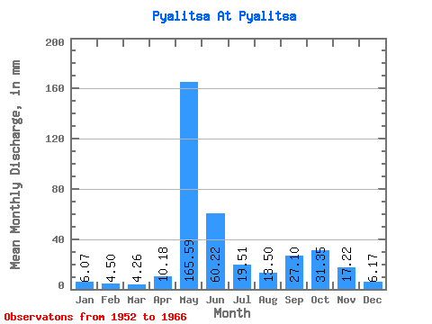
| Statistic | Jan | Feb | Mar | Apr | May | Jun | Jul | Aug | Sep | Oct | Nov | Dec | Annual |
|---|---|---|---|---|---|---|---|---|---|---|---|---|---|
| Mean | 6.07 | 4.54 | 4.26 | 10.18 | 165.56 | 60.22 | 19.50 | 13.49 | 27.10 | 31.34 | 17.22 | 6.17 | 358.15 |
| Standard Deviation | 2.88 | 2.23 | 2.09 | 16.18 | 62.57 | 48.01 | 12.59 | 9.86 | 20.62 | 14.83 | 12.84 | 2.14 | 92.44 |
| Min | 3.06 | 2.35 | 2.60 | 2.67 | 39.79 | 13.08 | 4.79 | 3.39 | 5.48 | 4.18 | 2.96 | 2.19 | 161.33 |
| Max | 13.62 | 11.64 | 11.25 | 64.43 | 229.80 | 177.98 | 44.89 | 38.26 | 83.69 | 56.62 | 47.15 | 10.61 | 523.29 |
| Coefficient of Variation | 0.47 | 0.49 | 0.49 | 1.59 | 0.38 | 0.80 | 0.65 | 0.73 | 0.76 | 0.47 | 0.75 | 0.35 | 0.26 |
 Return to R-Arctic Net Home Page