|
|
|||||||||||||||||
| Point ID: 7634 | Downloads | Plots | Site Data | Code: 71177 |
|
|
|||||||||||||||||
| Download | |
|---|---|
| Site Descriptor Information | Site Time Series Data |
| Link to all available data | |
| View: | Time Series | All |
| Units: | mm |
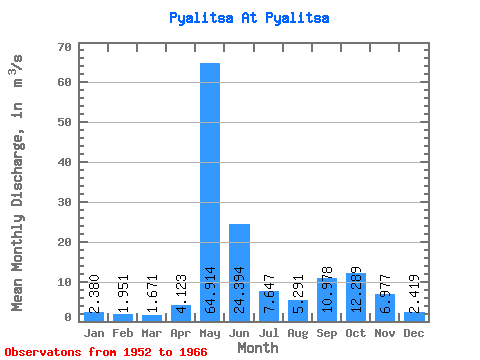
| Statistic | Jan | Feb | Mar | Apr | May | Jun | Jul | Aug | Sep | Oct | Nov | Dec | Annual |
|---|---|---|---|---|---|---|---|---|---|---|---|---|---|
| Mean | 2.38 | 1.95 | 1.67 | 4.12 | 64.91 | 24.39 | 7.65 | 5.29 | 10.98 | 12.29 | 6.98 | 2.42 | 11.92 |
| Standard Deviation | 1.13 | 0.96 | 0.82 | 6.55 | 24.53 | 19.45 | 4.94 | 3.86 | 8.35 | 5.81 | 5.20 | 0.84 | 3.08 |
| Min | 1.20 | 1.01 | 1.02 | 1.08 | 15.60 | 5.30 | 1.88 | 1.33 | 2.22 | 1.64 | 1.20 | 0.86 | 5.37 |
| Max | 5.34 | 5.01 | 4.41 | 26.10 | 90.10 | 72.10 | 17.60 | 15.00 | 33.90 | 22.20 | 19.10 | 4.16 | 17.41 |
| Coefficient of Variation | 0.47 | 0.49 | 0.49 | 1.59 | 0.38 | 0.80 | 0.65 | 0.73 | 0.76 | 0.47 | 0.75 | 0.35 | 0.26 |
 Return to R-Arctic Net Home Page