|
|
|||||||||||||||||
| Point ID: 7629 | Downloads | Plots | Site Data | Code: 71168 |
|
|
|||||||||||||||||
| Download | |
|---|---|
| Site Descriptor Information | Site Time Series Data |
| Link to all available data | |
| View: | Time Series | All |
| Units: | m3/s |
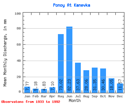
| Statistic | Jan | Feb | Mar | Apr | May | Jun | Jul | Aug | Sep | Oct | Nov | Dec | Annual |
|---|---|---|---|---|---|---|---|---|---|---|---|---|---|
| Mean | 7.77 | 5.22 | 4.83 | 7.10 | 73.00 | 82.23 | 37.63 | 28.05 | 31.35 | 30.45 | 18.05 | 11.57 | 336.42 |
| Standard Deviation | 1.79 | 1.15 | 1.17 | 6.29 | 38.54 | 28.85 | 11.59 | 10.72 | 10.99 | 11.79 | 8.15 | 3.67 | 62.34 |
| Min | 3.94 | 3.23 | 2.42 | 2.50 | 5.88 | 30.49 | 12.68 | 10.08 | 13.27 | 10.34 | 5.41 | 3.86 | 151.56 |
| Max | 12.47 | 8.23 | 7.80 | 37.10 | 148.08 | 143.32 | 68.79 | 57.24 | 54.13 | 57.24 | 40.91 | 22.16 | 501.74 |
| Coefficient of Variation | 0.23 | 0.22 | 0.24 | 0.89 | 0.53 | 0.35 | 0.31 | 0.38 | 0.35 | 0.39 | 0.45 | 0.32 | 0.18 |
 Return to R-Arctic Net Home Page