|
|
|||||||||||||||||
| Point ID: 7629 | Downloads | Plots | Site Data | Code: 71168 |
|
|
|||||||||||||||||
| Download | |
|---|---|
| Site Descriptor Information | Site Time Series Data |
| Link to all available data | |
| View: | Time Series | All |
| Units: | mm |
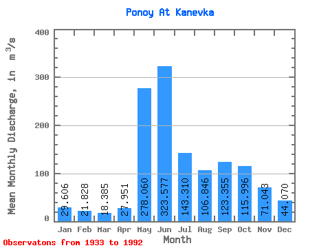
| Statistic | Jan | Feb | Mar | Apr | May | Jun | Jul | Aug | Sep | Oct | Nov | Dec | Annual |
|---|---|---|---|---|---|---|---|---|---|---|---|---|---|
| Mean | 29.61 | 21.83 | 18.39 | 27.95 | 278.06 | 323.58 | 143.31 | 106.85 | 123.36 | 116.00 | 71.04 | 44.07 | 108.73 |
| Standard Deviation | 6.80 | 4.81 | 4.46 | 24.74 | 146.79 | 113.54 | 44.13 | 40.82 | 43.27 | 44.91 | 32.09 | 13.99 | 20.15 |
| Min | 15.00 | 13.50 | 9.23 | 9.84 | 22.40 | 120.00 | 48.30 | 38.40 | 52.20 | 39.40 | 21.30 | 14.70 | 48.98 |
| Max | 47.50 | 34.40 | 29.70 | 146.00 | 564.00 | 564.00 | 262.00 | 218.00 | 213.00 | 218.00 | 161.00 | 84.40 | 162.16 |
| Coefficient of Variation | 0.23 | 0.22 | 0.24 | 0.89 | 0.53 | 0.35 | 0.31 | 0.38 | 0.35 | 0.39 | 0.45 | 0.32 | 0.18 |
 Return to R-Arctic Net Home Page