|
|
|||||||||||||||||
| Point ID: 7627 | Downloads | Plots | Site Data | Code: 71163 |
|
|
|||||||||||||||||
| Download | |
|---|---|
| Site Descriptor Information | Site Time Series Data |
| Link to all available data | |
| View: | Time Series | All |
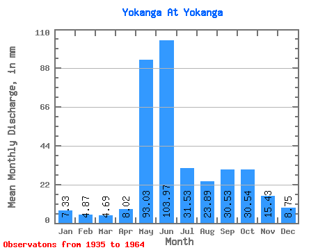
| Units: | m3/s |
| Statistic | Jan | Feb | Mar | Apr | May | Jun | Jul | Aug | Sep | Oct | Nov | Dec | Annual |
|---|---|---|---|---|---|---|---|---|---|---|---|---|---|
| Mean | 7.33 | 4.91 | 4.69 | 8.03 | 93.02 | 103.97 | 31.53 | 23.89 | 30.53 | 30.54 | 15.43 | 8.75 | 361.50 |
| Standard Deviation | 2.27 | 1.56 | 1.55 | 8.28 | 54.15 | 82.83 | 10.97 | 11.24 | 10.23 | 10.47 | 6.70 | 2.79 | 105.18 |
| Min | 3.71 | 3.33 | 2.99 | 2.75 | 5.34 | 31.52 | 15.16 | 9.95 | 14.99 | 18.42 | 6.55 | 4.81 | 228.53 |
| Max | 12.92 | 8.91 | 8.60 | 32.51 | 185.06 | 398.47 | 52.99 | 47.69 | 50.10 | 51.36 | 29.47 | 16.14 | 665.79 |
| Coefficient of Variation | 0.31 | 0.32 | 0.33 | 1.03 | 0.58 | 0.80 | 0.35 | 0.47 | 0.34 | 0.34 | 0.43 | 0.32 | 0.29 |
 Return to R-Arctic Net Home Page