|
|
|||||||||||||||||
| Point ID: 7627 | Downloads | Plots | Site Data | Code: 71163 |
|
|
|||||||||||||||||
| Download | |
|---|---|
| Site Descriptor Information | Site Time Series Data |
| Link to all available data | |
| View: | Time Series | All |
| Units: | mm |
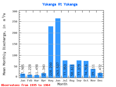
| Statistic | Jan | Feb | Mar | Apr | May | Jun | Jul | Aug | Sep | Oct | Nov | Dec | Annual |
|---|---|---|---|---|---|---|---|---|---|---|---|---|---|
| Mean | 17.98 | 13.23 | 11.50 | 20.34 | 228.20 | 263.54 | 77.35 | 58.61 | 77.38 | 74.92 | 39.11 | 21.47 | 75.25 |
| Standard Deviation | 5.56 | 4.19 | 3.80 | 20.98 | 132.84 | 209.96 | 26.90 | 27.59 | 25.92 | 25.68 | 16.99 | 6.84 | 21.90 |
| Min | 9.11 | 8.97 | 7.33 | 6.96 | 13.10 | 79.90 | 37.20 | 24.40 | 38.00 | 45.20 | 16.60 | 11.80 | 47.58 |
| Max | 31.70 | 24.00 | 21.10 | 82.40 | 454.00 | 1010.00 | 130.00 | 117.00 | 127.00 | 126.00 | 74.70 | 39.60 | 138.60 |
| Coefficient of Variation | 0.31 | 0.32 | 0.33 | 1.03 | 0.58 | 0.80 | 0.35 | 0.47 | 0.34 | 0.34 | 0.43 | 0.32 | 0.29 |
 Return to R-Arctic Net Home Page