|
|
|||||||||||||||||
| Point ID: 7623 | Downloads | Plots | Site Data | Code: 71159 |
|
|
|||||||||||||||||
| Download | |
|---|---|
| Site Descriptor Information | Site Time Series Data |
| Link to all available data | |
| View: | Time Series | All |
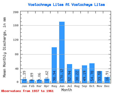
| Units: | m3/s |
| Statistic | Jan | Feb | Mar | Apr | May | Jun | Jul | Aug | Sep | Oct | Nov | Dec | Annual |
|---|---|---|---|---|---|---|---|---|---|---|---|---|---|
| Mean | 11.38 | 8.96 | 9.06 | 11.62 | 98.92 | 170.12 | 52.93 | 38.22 | 49.19 | 54.77 | 33.58 | 16.91 | 559.71 |
| Standard Deviation | 3.98 | 3.93 | 3.88 | 8.38 | 60.47 | 77.57 | 23.08 | 15.21 | 16.43 | 21.09 | 14.37 | 5.08 | 104.90 |
| Min | 5.81 | 3.39 | 3.42 | 3.60 | 8.95 | 34.61 | 10.79 | 5.45 | 23.18 | 21.58 | 14.45 | 10.65 | 319.64 |
| Max | 21.27 | 15.93 | 18.59 | 43.30 | 198.49 | 295.79 | 97.35 | 70.26 | 89.81 | 97.51 | 64.65 | 29.30 | 746.07 |
| Coefficient of Variation | 0.35 | 0.44 | 0.43 | 0.72 | 0.61 | 0.46 | 0.44 | 0.40 | 0.33 | 0.39 | 0.43 | 0.30 | 0.19 |
 Return to R-Arctic Net Home Page