|
|
|||||||||||||||||
| Point ID: 7623 | Downloads | Plots | Site Data | Code: 71159 |
|
|
|||||||||||||||||
| Download | |
|---|---|
| Site Descriptor Information | Site Time Series Data |
| Link to all available data | |
|
|
| View: | Statistics | Time Series |
| Units: | m3/s |
| Statistic | Jan | Feb | Mar | Apr | May | Jun | Jul | Aug | Sep | Oct | Nov | Dec | Annual |
|---|---|---|---|---|---|---|---|---|---|---|---|---|---|
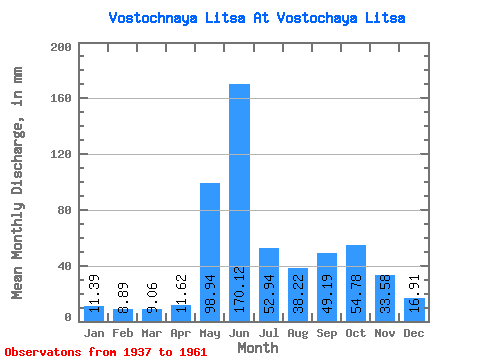
| Mean | 11.38 | 8.96 | 9.06 | 11.62 | 98.92 | 170.12 | 52.93 | 38.22 | 49.19 | 54.77 | 33.58 | 16.91 | 559.71 |
| Standard Deviation | 3.98 | 3.93 | 3.88 | 8.38 | 60.47 | 77.57 | 23.08 | 15.21 | 16.43 | 21.09 | 14.37 | 5.08 | 104.90 |
| Min | 5.81 | 3.39 | 3.42 | 3.60 | 8.95 | 34.61 | 10.79 | 5.45 | 23.18 | 21.58 | 14.45 | 10.65 | 319.64 |
| Max | 21.27 | 15.93 | 18.59 | 43.30 | 198.49 | 295.79 | 97.35 | 70.26 | 89.81 | 97.51 | 64.65 | 29.30 | 746.07 |
| Coefficient of Variation | 0.35 | 0.44 | 0.43 | 0.72 | 0.61 | 0.46 | 0.44 | 0.40 | 0.33 | 0.39 | 0.43 | 0.30 | 0.19 |
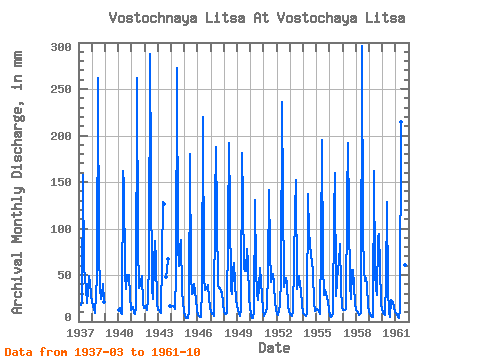
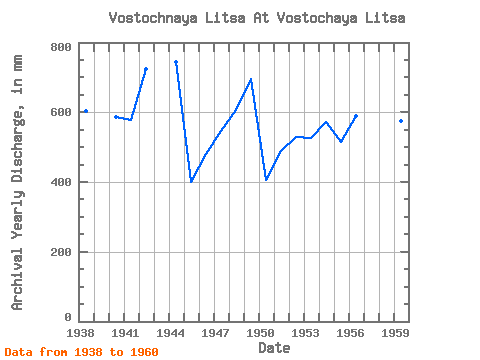
| Year | Jan | Feb | Mar | Apr | May | Jun | Jul | Aug | Sep | Oct | Nov | Dec | Annual | 1937 | 18.59 | 19.36 | 162.25 | 58.85 | 36.23 | 20.32 | 33.24 | 50.41 | 41.93 | 29.30 | 1938 | 21.27 | 15.93 | 13.60 | 9.45 | 49.15 | 262.25 | 76.24 | 35.92 | 24.55 | 29.62 | 40.71 | 22.21 | 602.63 | 1940 | 12.76 | 14.14 | 9.07 | 7.87 | 166.98 | 147.44 | 53.09 | 35.76 | 49.86 | 51.20 | 26.99 | 13.29 | 586.82 | 1941 | 14.51 | 14.93 | 9.99 | 7.71 | 14.89 | 262.25 | 86.01 | 37.49 | 43.61 | 50.57 | 19.52 | 14.89 | 578.31 | 1942 | 16.70 | 14.64 | 12.76 | 23.94 | 66.79 | 288.17 | 35.60 | 24.57 | 64.34 | 89.95 | 64.65 | 20.48 | 725.42 | 1943 | 13.12 | 11.22 | 10.08 | 9.00 | 133.27 | 125.94 | 49.62 | 54.58 | 69.47 | 17.49 | 1944 | 15.91 | 15.36 | 16.07 | 13.22 | 52.77 | 272.92 | 84.12 | 62.07 | 79.59 | 90.42 | 31.87 | 10.68 | 746.07 | 1945 | 5.81 | 3.39 | 3.88 | 3.60 | 12.15 | 179.91 | 50.57 | 30.25 | 30.95 | 41.59 | 24.24 | 12.62 | 399.90 | 1946 | 7.37 | 5.44 | 5.29 | 5.09 | 36.70 | 219.56 | 49.78 | 34.66 | 34.92 | 40.64 | 24.70 | 15.60 | 480.93 | 1947 | 10.49 | 8.00 | 7.81 | 5.64 | 131.38 | 187.54 | 38.91 | 36.70 | 35.83 | 32.45 | 31.71 | 20.16 | 546.10 | 1948 | 10.43 | 8.04 | 8.43 | 8.90 | 198.49 | 121.82 | 35.92 | 30.72 | 55.50 | 65.22 | 41.17 | 24.26 | 606.15 | 1949 | 16.70 | 7.12 | 6.60 | 13.08 | 187.46 | 129.45 | 59.86 | 55.92 | 54.58 | 80.50 | 63.27 | 24.89 | 696.07 | 1950 | 7.23 | 3.66 | 3.42 | 11.42 | 134.53 | 56.26 | 31.03 | 24.42 | 37.51 | 59.70 | 27.75 | 12.24 | 406.52 | 1951 | 6.00 | 7.81 | 11.64 | 13.10 | 58.13 | 141.03 | 79.55 | 43.64 | 51.53 | 42.22 | 20.13 | 13.80 | 487.93 | 1952 | 8.54 | 6.37 | 12.13 | 18.75 | 45.68 | 236.33 | 38.12 | 44.58 | 47.11 | 42.22 | 17.84 | 10.76 | 530.01 | 1953 | 8.44 | 6.40 | 6.54 | 9.99 | 123.19 | 152.17 | 35.76 | 43.95 | 49.40 | 39.23 | 33.39 | 18.12 | 525.72 | 1954 | 9.85 | 6.34 | 6.14 | 7.96 | 141.15 | 95.29 | 88.69 | 70.26 | 66.33 | 52.46 | 20.89 | 11.40 | 573.23 | 1955 | 13.85 | 11.24 | 10.44 | 8.08 | 83.65 | 195.16 | 63.80 | 29.30 | 33.70 | 31.19 | 20.58 | 13.60 | 514.83 | 1956 | 6.32 | 4.23 | 5.61 | 9.48 | 118.31 | 160.09 | 27.88 | 60.81 | 61.75 | 86.01 | 36.29 | 15.63 | 590.91 | 1957 | 12.51 | 11.53 | 12.41 | 13.33 | 135.47 | 192.11 | 40.48 | 24.73 | 54.89 | 56.71 | 38.73 | 19.69 | 612.47 | 1958 | 13.22 | 10.13 | 9.15 | 7.12 | 8.95 | 295.79 | 97.35 | 56.71 | 43.61 | 48.20 | 38.12 | 17.49 | 647.77 | 1959 | 11.94 | 5.68 | 4.90 | 5.26 | 166.98 | 52.91 | 36.23 | 28.98 | 89.81 | 97.51 | 59.77 | 19.69 | 576.59 | 1960 | 8.95 | 7.41 | 7.59 | 43.30 | 132.96 | 34.61 | 10.79 | 5.45 | 23.18 | 21.58 | 14.45 | 10.65 | 319.64 | 1961 | 9.92 | 7.16 | 5.25 | 4.28 | 12.85 | 214.98 | 61.44 | 30.40 | 60.23 | 45.37 |
|---|
 Return to R-Arctic Net Home Page