|
|
|||||||||||||||||
| Point ID: 7600 | Downloads | Plots | Site Data | Code: 71104 |
|
|
|||||||||||||||||
| Download | |
|---|---|
| Site Descriptor Information | Site Time Series Data |
| Link to all available data | |
| View: | Time Series | All |
| Units: | m3/s |
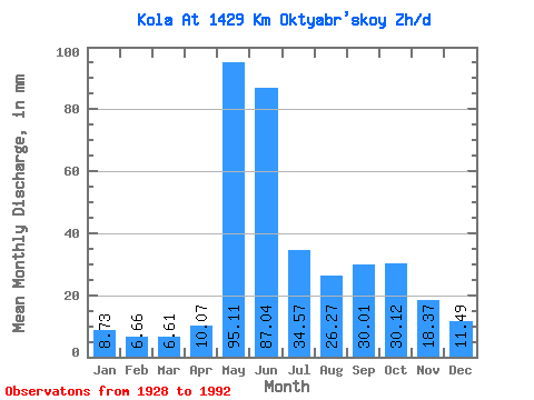
| Statistic | Jan | Feb | Mar | Apr | May | Jun | Jul | Aug | Sep | Oct | Nov | Dec | Annual |
|---|---|---|---|---|---|---|---|---|---|---|---|---|---|
| Mean | 8.73 | 6.72 | 6.61 | 10.07 | 95.10 | 87.04 | 34.57 | 26.26 | 30.01 | 30.11 | 18.38 | 11.49 | 365.19 |
| Standard Deviation | 2.26 | 1.91 | 2.12 | 9.06 | 44.11 | 41.95 | 18.61 | 12.57 | 15.53 | 11.64 | 7.19 | 2.86 | 78.82 |
| Min | 4.73 | 3.19 | 2.70 | 2.98 | 23.38 | 18.93 | 11.05 | 6.78 | 12.41 | 10.13 | 6.42 | 5.75 | 183.01 |
| Max | 14.59 | 12.97 | 12.75 | 59.66 | 199.08 | 181.71 | 98.48 | 59.72 | 117.26 | 55.33 | 50.47 | 20.12 | 535.39 |
| Coefficient of Variation | 0.26 | 0.28 | 0.32 | 0.90 | 0.46 | 0.48 | 0.54 | 0.48 | 0.52 | 0.39 | 0.39 | 0.25 | 0.22 |
 Return to R-Arctic Net Home Page