|
|
|||||||||||||||||
| Point ID: 7600 | Downloads | Plots | Site Data | Code: 71104 |
|
|
|||||||||||||||||
| Download | |
|---|---|
| Site Descriptor Information | Site Time Series Data |
| Link to all available data | |
| View: | Time Series | All |
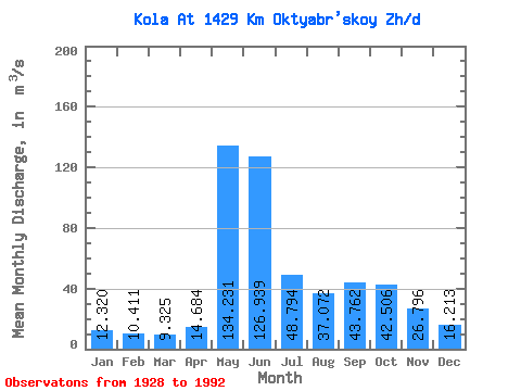
| Units: | mm |
| Statistic | Jan | Feb | Mar | Apr | May | Jun | Jul | Aug | Sep | Oct | Nov | Dec | Annual |
|---|---|---|---|---|---|---|---|---|---|---|---|---|---|
| Mean | 12.32 | 10.41 | 9.32 | 14.68 | 134.23 | 126.94 | 48.79 | 37.07 | 43.76 | 42.51 | 26.80 | 16.21 | 43.74 |
| Standard Deviation | 3.19 | 2.96 | 2.99 | 13.21 | 62.26 | 61.17 | 26.27 | 17.75 | 22.65 | 16.43 | 10.49 | 4.03 | 9.44 |
| Min | 6.68 | 4.95 | 3.81 | 4.35 | 33.00 | 27.60 | 15.60 | 9.57 | 18.10 | 14.30 | 9.37 | 8.12 | 21.92 |
| Max | 20.60 | 20.10 | 18.00 | 87.00 | 281.00 | 265.00 | 139.00 | 84.30 | 171.00 | 78.10 | 73.60 | 28.40 | 64.12 |
| Coefficient of Variation | 0.26 | 0.28 | 0.32 | 0.90 | 0.46 | 0.48 | 0.54 | 0.48 | 0.52 | 0.39 | 0.39 | 0.25 | 0.22 |
 Return to R-Arctic Net Home Page