|
|
|||||||||||||||||
| Point ID: 7573 | Downloads | Plots | Site Data | Code: 71018 |
|
|
|||||||||||||||||
| Download | |
|---|---|
| Site Descriptor Information | Site Time Series Data |
| Link to all available data | |
| View: | Time Series | All |
| Units: | m3/s |
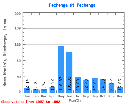
| Statistic | Jan | Feb | Mar | Apr | May | Jun | Jul | Aug | Sep | Oct | Nov | Dec | Annual |
|---|---|---|---|---|---|---|---|---|---|---|---|---|---|
| Mean | 12.14 | 9.20 | 8.73 | 13.92 | 116.35 | 101.03 | 39.62 | 32.43 | 37.01 | 34.29 | 24.32 | 15.65 | 439.04 |
| Standard Deviation | 2.39 | 1.79 | 1.67 | 11.44 | 52.45 | 46.02 | 21.12 | 17.19 | 20.30 | 12.13 | 10.34 | 3.64 | 94.08 |
| Min | 5.96 | 5.65 | 4.78 | 4.69 | 35.23 | 40.42 | 13.33 | 10.46 | 13.10 | 12.13 | 7.75 | 7.01 | 275.49 |
| Max | 17.69 | 15.11 | 12.99 | 56.16 | 247.08 | 209.83 | 89.43 | 84.64 | 106.61 | 68.70 | 69.27 | 26.30 | 617.14 |
| Coefficient of Variation | 0.20 | 0.19 | 0.19 | 0.82 | 0.45 | 0.46 | 0.53 | 0.53 | 0.55 | 0.35 | 0.42 | 0.23 | 0.21 |
 Return to R-Arctic Net Home Page