|
|
|||||||||||||||||
| Point ID: 7573 | Downloads | Plots | Site Data | Code: 71018 |
|
|
|||||||||||||||||
| Download | |
|---|---|
| Site Descriptor Information | Site Time Series Data |
| Link to all available data | |
| View: | Time Series | All |
| Units: | mm |
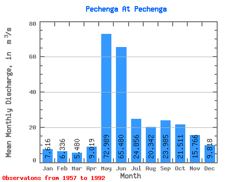
| Statistic | Jan | Feb | Mar | Apr | May | Jun | Jul | Aug | Sep | Oct | Nov | Dec | Annual |
|---|---|---|---|---|---|---|---|---|---|---|---|---|---|
| Mean | 7.62 | 6.34 | 5.48 | 9.02 | 72.99 | 65.48 | 24.86 | 20.34 | 23.98 | 21.51 | 15.77 | 9.82 | 23.37 |
| Standard Deviation | 1.50 | 1.23 | 1.05 | 7.42 | 32.90 | 29.83 | 13.25 | 10.78 | 13.15 | 7.61 | 6.70 | 2.28 | 5.01 |
| Min | 3.74 | 3.89 | 3.00 | 3.04 | 22.10 | 26.20 | 8.36 | 6.56 | 8.49 | 7.61 | 5.02 | 4.40 | 14.66 |
| Max | 11.10 | 10.40 | 8.15 | 36.40 | 155.00 | 136.00 | 56.10 | 53.10 | 69.10 | 43.10 | 44.90 | 16.50 | 32.85 |
| Coefficient of Variation | 0.20 | 0.19 | 0.19 | 0.82 | 0.45 | 0.46 | 0.53 | 0.53 | 0.55 | 0.35 | 0.42 | 0.23 | 0.21 |
 Return to R-Arctic Net Home Page