|
|
|||||||||||||||||
| Point ID: 757 | Downloads | Plots | Site Data | Code: 07GF001 |
|
|
|||||||||||||||||
| Download | |
|---|---|
| Site Descriptor Information | Site Time Series Data |
| Link to all available data | |
| View: | Time Series | All |
| Units: | m3/s |
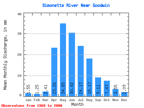
| Statistic | Jan | Feb | Mar | Apr | May | Jun | Jul | Aug | Sep | Oct | Nov | Dec | Annual |
|---|---|---|---|---|---|---|---|---|---|---|---|---|---|
| Mean | 1.54 | 1.26 | 2.41 | 23.26 | 34.84 | 30.42 | 24.17 | 18.17 | 9.11 | 7.46 | 3.55 | 2.09 | 170.60 |
| Standard Deviation | 0.62 | 0.47 | 2.80 | 14.54 | 21.05 | 21.52 | 22.12 | 33.35 | 7.08 | 5.70 | 1.46 | 0.95 | 47.29 |
| Min | 0.41 | 0.46 | 0.77 | 3.18 | 7.00 | 6.16 | 3.48 | 2.44 | 1.98 | 1.81 | 1.02 | 0.69 | 74.22 |
| Max | 2.36 | 1.92 | 16.76 | 65.19 | 102.35 | 90.85 | 93.33 | 182.42 | 28.49 | 26.94 | 6.21 | 4.31 | 236.35 |
| Coefficient of Variation | 0.40 | 0.37 | 1.16 | 0.62 | 0.60 | 0.71 | 0.92 | 1.83 | 0.78 | 0.76 | 0.41 | 0.45 | 0.28 |
 Return to R-Arctic Net Home Page