|
|
|||||||||||||||||
| Point ID: 757 | Downloads | Plots | Site Data | Code: 07GF001 |
|
|
|||||||||||||||||
| Download | |
|---|---|
| Site Descriptor Information | Site Time Series Data |
| Link to all available data | |
| View: | Time Series | All |
| Units: | mm |
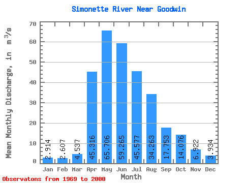
| Statistic | Jan | Feb | Mar | Apr | May | Jun | Jul | Aug | Sep | Oct | Nov | Dec | Annual |
|---|---|---|---|---|---|---|---|---|---|---|---|---|---|
| Mean | 2.91 | 2.61 | 4.54 | 45.32 | 65.71 | 59.27 | 45.58 | 34.26 | 17.75 | 14.08 | 6.92 | 3.93 | 27.30 |
| Standard Deviation | 1.18 | 0.97 | 5.28 | 28.32 | 39.69 | 41.93 | 41.71 | 62.89 | 13.80 | 10.74 | 2.84 | 1.79 | 7.57 |
| Min | 0.77 | 0.95 | 1.45 | 6.19 | 13.20 | 12.00 | 6.57 | 4.61 | 3.85 | 3.42 | 1.99 | 1.30 | 11.88 |
| Max | 4.45 | 3.98 | 31.60 | 127.00 | 193.00 | 177.00 | 176.00 | 344.00 | 55.50 | 50.80 | 12.10 | 8.12 | 37.82 |
| Coefficient of Variation | 0.40 | 0.37 | 1.16 | 0.62 | 0.60 | 0.71 | 0.92 | 1.83 | 0.78 | 0.76 | 0.41 | 0.45 | 0.28 |
 Return to R-Arctic Net Home Page