|
|
|||||||||||||||||
| Point ID: 7515 | Downloads | Plots | Site Data | Code: 70522 |
|
|
|||||||||||||||||
| Download | |
|---|---|
| Site Descriptor Information | Site Time Series Data |
| Link to all available data | |
| View: | Time Series | All |
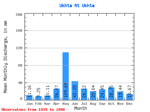
| Units: | m3/s |
| Statistic | Jan | Feb | Mar | Apr | May | Jun | Jul | Aug | Sep | Oct | Nov | Dec | Annual |
|---|---|---|---|---|---|---|---|---|---|---|---|---|---|
| Mean | 11.15 | 9.33 | 10.11 | 26.07 | 109.68 | 43.05 | 26.11 | 20.64 | 24.45 | 28.74 | 19.45 | 13.66 | 341.24 |
| Standard Deviation | 1.90 | 1.41 | 1.59 | 23.11 | 33.74 | 18.73 | 11.09 | 7.64 | 13.81 | 10.15 | 5.84 | 3.07 | 51.27 |
| Min | 6.74 | 6.54 | 6.68 | 6.46 | 37.08 | 18.13 | 12.80 | 11.11 | 12.14 | 14.11 | 11.90 | 8.24 | 227.01 |
| Max | 15.36 | 13.76 | 14.79 | 109.96 | 190.39 | 97.28 | 74.28 | 57.74 | 109.36 | 59.18 | 35.77 | 25.41 | 461.94 |
| Coefficient of Variation | 0.17 | 0.15 | 0.16 | 0.89 | 0.31 | 0.43 | 0.42 | 0.37 | 0.56 | 0.35 | 0.30 | 0.23 | 0.15 |
 Return to R-Arctic Net Home Page