|
|
|||||||||||||||||
| Point ID: 7515 | Downloads | Plots | Site Data | Code: 70522 |
|
|
|||||||||||||||||
| Download | |
|---|---|
| Site Descriptor Information | Site Time Series Data |
| Link to all available data | |
| View: | Time Series | All |
| Units: | mm |
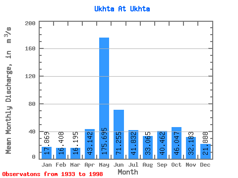
| Statistic | Jan | Feb | Mar | Apr | May | Jun | Jul | Aug | Sep | Oct | Nov | Dec | Annual |
|---|---|---|---|---|---|---|---|---|---|---|---|---|---|
| Mean | 17.87 | 16.41 | 16.20 | 43.14 | 175.69 | 71.25 | 41.83 | 33.06 | 40.46 | 46.05 | 32.18 | 21.89 | 46.38 |
| Standard Deviation | 3.05 | 2.47 | 2.55 | 38.25 | 54.05 | 30.99 | 17.77 | 12.24 | 22.85 | 16.26 | 9.67 | 4.92 | 6.97 |
| Min | 10.80 | 11.50 | 10.70 | 10.70 | 59.40 | 30.00 | 20.50 | 17.80 | 20.10 | 22.60 | 19.70 | 13.20 | 30.86 |
| Max | 24.60 | 24.20 | 23.70 | 182.00 | 305.00 | 161.00 | 119.00 | 92.50 | 181.00 | 94.80 | 59.20 | 40.70 | 62.79 |
| Coefficient of Variation | 0.17 | 0.15 | 0.16 | 0.89 | 0.31 | 0.43 | 0.42 | 0.37 | 0.56 | 0.35 | 0.30 | 0.23 | 0.15 |
 Return to R-Arctic Net Home Page