|
|
|||||||||||||||||
| Point ID: 7514 | Downloads | Plots | Site Data | Code: 70518 |
|
|
|||||||||||||||||
| Download | |
|---|---|
| Site Descriptor Information | Site Time Series Data |
| Link to all available data | |
| View: | Time Series | All |
| Units: | m3/s |
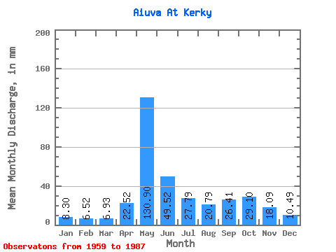
| Statistic | Jan | Feb | Mar | Apr | May | Jun | Jul | Aug | Sep | Oct | Nov | Dec | Annual |
|---|---|---|---|---|---|---|---|---|---|---|---|---|---|
| Mean | 8.30 | 6.57 | 6.93 | 22.52 | 130.88 | 49.52 | 27.79 | 20.79 | 26.41 | 29.10 | 18.09 | 10.49 | 354.01 |
| Standard Deviation | 1.35 | 0.98 | 1.03 | 26.88 | 38.89 | 29.47 | 21.46 | 15.04 | 9.54 | 11.32 | 8.18 | 2.73 | 58.04 |
| Min | 6.57 | 4.31 | 4.89 | 5.76 | 60.90 | 17.24 | 9.31 | 7.75 | 9.54 | 14.95 | 8.70 | 6.66 | 267.14 |
| Max | 11.65 | 9.40 | 9.52 | 111.44 | 197.11 | 140.78 | 94.34 | 85.37 | 53.81 | 56.14 | 39.87 | 18.35 | 481.21 |
| Coefficient of Variation | 0.16 | 0.15 | 0.15 | 1.19 | 0.30 | 0.59 | 0.77 | 0.72 | 0.36 | 0.39 | 0.45 | 0.26 | 0.16 |
 Return to R-Arctic Net Home Page