|
|
|||||||||||||||||
| Point ID: 7514 | Downloads | Plots | Site Data | Code: 70518 |
|
|
|||||||||||||||||
| Download | |
|---|---|
| Site Descriptor Information | Site Time Series Data |
| Link to all available data | |
| View: | Time Series | All |
| Units: | mm |
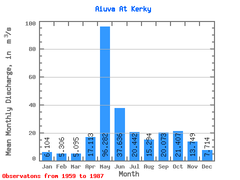
| Statistic | Jan | Feb | Mar | Apr | May | Jun | Jul | Aug | Sep | Oct | Nov | Dec | Annual |
|---|---|---|---|---|---|---|---|---|---|---|---|---|---|
| Mean | 6.10 | 5.31 | 5.09 | 17.11 | 96.28 | 37.64 | 20.44 | 15.29 | 20.07 | 21.41 | 13.75 | 7.71 | 22.10 |
| Standard Deviation | 0.99 | 0.79 | 0.76 | 20.43 | 28.61 | 22.40 | 15.79 | 11.06 | 7.25 | 8.32 | 6.22 | 2.01 | 3.62 |
| Min | 4.83 | 3.48 | 3.60 | 4.38 | 44.80 | 13.10 | 6.85 | 5.70 | 7.25 | 11.00 | 6.61 | 4.90 | 16.68 |
| Max | 8.57 | 7.59 | 7.00 | 84.70 | 145.00 | 107.00 | 69.40 | 62.80 | 40.90 | 41.30 | 30.30 | 13.50 | 30.04 |
| Coefficient of Variation | 0.16 | 0.15 | 0.15 | 1.19 | 0.30 | 0.59 | 0.77 | 0.72 | 0.36 | 0.39 | 0.45 | 0.26 | 0.16 |
 Return to R-Arctic Net Home Page