|
|
|||||||||||||||||
| Point ID: 7511 | Downloads | Plots | Site Data | Code: 70512 |
|
|
|||||||||||||||||
| Download | |
|---|---|
| Site Descriptor Information | Site Time Series Data |
| Link to all available data | |
| View: | Time Series | All |
| Units: | m3/s |
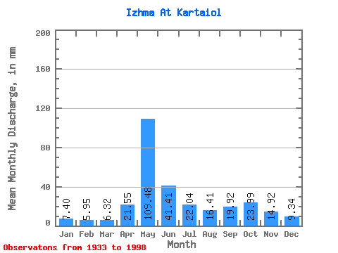
| Statistic | Jan | Feb | Mar | Apr | May | Jun | Jul | Aug | Sep | Oct | Nov | Dec | Annual |
|---|---|---|---|---|---|---|---|---|---|---|---|---|---|
| Mean | 7.39 | 6.00 | 6.32 | 21.55 | 109.46 | 41.41 | 22.03 | 16.40 | 19.92 | 23.99 | 14.92 | 9.34 | 297.42 |
| Standard Deviation | 1.47 | 1.01 | 1.01 | 24.56 | 31.50 | 18.96 | 11.65 | 9.03 | 9.89 | 9.55 | 5.49 | 2.38 | 49.47 |
| Min | 2.90 | 2.84 | 2.95 | 3.88 | 37.75 | 16.56 | 9.77 | 6.82 | 7.21 | 8.25 | 3.67 | 4.12 | 171.95 |
| Max | 11.91 | 8.97 | 8.40 | 111.33 | 192.30 | 112.36 | 69.13 | 62.29 | 64.52 | 48.13 | 33.80 | 18.40 | 422.90 |
| Coefficient of Variation | 0.20 | 0.17 | 0.16 | 1.14 | 0.29 | 0.46 | 0.53 | 0.55 | 0.50 | 0.40 | 0.37 | 0.26 | 0.17 |
 Return to R-Arctic Net Home Page