|
|
|||||||||||||||||
| Point ID: 7511 | Downloads | Plots | Site Data | Code: 70512 |
|
|
|||||||||||||||||
| Download | |
|---|---|
| Site Descriptor Information | Site Time Series Data |
| Link to all available data | |
| View: | Time Series | All |
| Units: | mm |
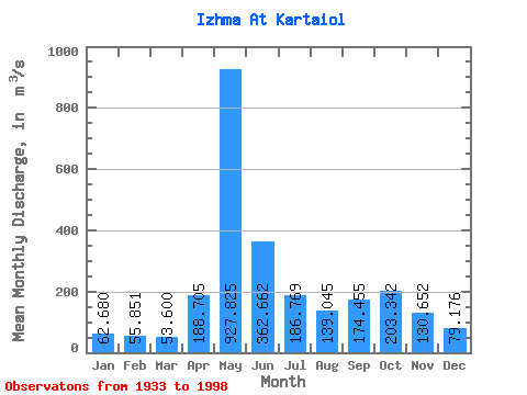
| Statistic | Jan | Feb | Mar | Apr | May | Jun | Jul | Aug | Sep | Oct | Nov | Dec | Annual |
|---|---|---|---|---|---|---|---|---|---|---|---|---|---|
| Mean | 62.68 | 55.85 | 53.60 | 188.71 | 927.83 | 362.66 | 186.77 | 139.04 | 174.46 | 203.34 | 130.65 | 79.18 | 213.93 |
| Standard Deviation | 12.49 | 9.40 | 8.54 | 215.10 | 267.04 | 166.07 | 98.74 | 76.51 | 86.61 | 80.95 | 48.04 | 20.21 | 35.58 |
| Min | 24.60 | 26.40 | 25.00 | 34.00 | 320.00 | 145.00 | 82.80 | 57.80 | 63.10 | 69.90 | 32.10 | 34.90 | 123.67 |
| Max | 101.00 | 83.50 | 71.20 | 975.00 | 1630.00 | 984.00 | 586.00 | 528.00 | 565.00 | 408.00 | 296.00 | 156.00 | 304.18 |
| Coefficient of Variation | 0.20 | 0.17 | 0.16 | 1.14 | 0.29 | 0.46 | 0.53 | 0.55 | 0.50 | 0.40 | 0.37 | 0.26 | 0.17 |
 Return to R-Arctic Net Home Page