|
|
|||||||||||||||||
| Point ID: 7510 | Downloads | Plots | Site Data | Code: 70509 |
|
|
|||||||||||||||||
| Download | |
|---|---|
| Site Descriptor Information | Site Time Series Data |
| Link to all available data | |
| View: | Time Series | All |
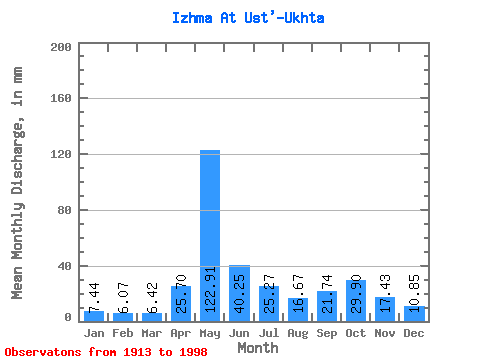
| Units: | m3/s |
| Statistic | Jan | Feb | Mar | Apr | May | Jun | Jul | Aug | Sep | Oct | Nov | Dec | Annual |
|---|---|---|---|---|---|---|---|---|---|---|---|---|---|
| Mean | 7.44 | 6.12 | 6.41 | 25.70 | 122.90 | 40.25 | 25.26 | 16.67 | 21.74 | 29.89 | 17.43 | 10.85 | 326.19 |
| Standard Deviation | 1.80 | 1.39 | 1.55 | 27.34 | 35.62 | 18.73 | 25.93 | 11.94 | 16.61 | 43.38 | 16.45 | 11.54 | 108.36 |
| Min | 3.87 | 3.03 | 2.86 | 2.04 | 44.28 | 15.17 | 5.84 | 4.54 | 4.72 | 6.50 | 3.30 | 4.66 | 175.30 |
| Max | 11.82 | 9.24 | 10.34 | 116.47 | 196.39 | 100.92 | 166.75 | 69.98 | 120.10 | 378.49 | 140.83 | 102.83 | 1084.84 |
| Coefficient of Variation | 0.24 | 0.23 | 0.24 | 1.06 | 0.29 | 0.47 | 1.03 | 0.72 | 0.76 | 1.45 | 0.94 | 1.06 | 0.33 |
 Return to R-Arctic Net Home Page