|
|
|||||||||||||||||
| Point ID: 7510 | Downloads | Plots | Site Data | Code: 70509 |
|
|
|||||||||||||||||
| Download | |
|---|---|
| Site Descriptor Information | Site Time Series Data |
| Link to all available data | |
| View: | Time Series | All |
| Units: | mm |
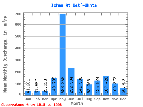
| Statistic | Jan | Feb | Mar | Apr | May | Jun | Jul | Aug | Sep | Oct | Nov | Dec | Annual |
|---|---|---|---|---|---|---|---|---|---|---|---|---|---|
| Mean | 41.66 | 37.66 | 35.93 | 148.74 | 688.37 | 232.90 | 141.51 | 93.37 | 125.82 | 167.43 | 100.87 | 60.78 | 155.03 |
| Standard Deviation | 10.08 | 8.51 | 8.70 | 158.22 | 199.54 | 108.42 | 145.25 | 66.87 | 96.12 | 242.98 | 95.18 | 64.65 | 51.50 |
| Min | 21.70 | 18.60 | 16.00 | 11.80 | 248.00 | 87.80 | 32.70 | 25.40 | 27.30 | 36.40 | 19.10 | 26.10 | 83.32 |
| Max | 66.20 | 56.80 | 57.90 | 674.00 | 1100.00 | 584.00 | 934.00 | 392.00 | 695.00 | 2120.00 | 815.00 | 576.00 | 515.61 |
| Coefficient of Variation | 0.24 | 0.23 | 0.24 | 1.06 | 0.29 | 0.47 | 1.03 | 0.72 | 0.76 | 1.45 | 0.94 | 1.06 | 0.33 |
 Return to R-Arctic Net Home Page