|
|
|||||||||||||||||
| Point ID: 751 | Downloads | Plots | Site Data | Code: 07GE001 |
|
|
|||||||||||||||||
| Download | |
|---|---|
| Site Descriptor Information | Site Time Series Data |
| Link to all available data | |
| View: | Time Series | All |
| Units: | m3/s |
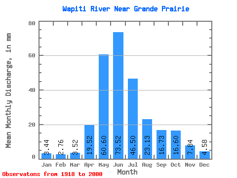
| Statistic | Jan | Feb | Mar | Apr | May | Jun | Jul | Aug | Sep | Oct | Nov | Dec | Annual |
|---|---|---|---|---|---|---|---|---|---|---|---|---|---|
| Mean | 3.38 | 2.73 | 3.45 | 19.17 | 59.52 | 72.22 | 45.67 | 22.72 | 16.43 | 16.30 | 7.70 | 4.50 | 272.92 |
| Standard Deviation | 1.03 | 0.90 | 1.98 | 11.44 | 21.08 | 31.94 | 24.80 | 19.00 | 10.43 | 8.58 | 3.16 | 1.67 | 80.13 |
| Min | 1.85 | 1.12 | 1.54 | 4.52 | 19.72 | 24.31 | 12.44 | 5.57 | 5.44 | 5.31 | 2.89 | 2.16 | 141.41 |
| Max | 6.11 | 5.01 | 12.49 | 48.63 | 115.42 | 178.46 | 117.78 | 85.32 | 43.35 | 38.63 | 14.63 | 9.20 | 469.30 |
| Coefficient of Variation | 0.30 | 0.33 | 0.57 | 0.60 | 0.35 | 0.44 | 0.54 | 0.84 | 0.64 | 0.53 | 0.41 | 0.37 | 0.29 |
 Return to R-Arctic Net Home Page