|
|
|||||||||||||||||
| Point ID: 751 | Downloads | Plots | Site Data | Code: 07GE001 |
|
|
|||||||||||||||||
| Download | |
|---|---|
| Site Descriptor Information | Site Time Series Data |
| Link to all available data | |
| View: | Time Series | All |
| Units: | mm |
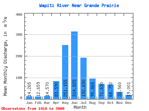
| Statistic | Jan | Feb | Mar | Apr | May | Jun | Jul | Aug | Sep | Oct | Nov | Dec | Annual |
|---|---|---|---|---|---|---|---|---|---|---|---|---|---|
| Mean | 14.27 | 12.66 | 14.57 | 83.59 | 251.16 | 314.82 | 192.69 | 95.86 | 71.63 | 68.79 | 33.56 | 19.00 | 97.72 |
| Standard Deviation | 4.34 | 4.18 | 8.37 | 49.87 | 88.95 | 139.24 | 104.63 | 80.18 | 45.46 | 36.20 | 13.79 | 7.06 | 28.69 |
| Min | 7.79 | 5.20 | 6.49 | 19.70 | 83.20 | 106.00 | 52.50 | 23.50 | 23.70 | 22.40 | 12.60 | 9.12 | 50.63 |
| Max | 25.80 | 23.20 | 52.70 | 212.00 | 487.00 | 778.00 | 497.00 | 360.00 | 189.00 | 163.00 | 63.80 | 38.80 | 168.03 |
| Coefficient of Variation | 0.30 | 0.33 | 0.57 | 0.60 | 0.35 | 0.44 | 0.54 | 0.84 | 0.64 | 0.53 | 0.41 | 0.37 | 0.29 |
 Return to R-Arctic Net Home Page