|
|
|||||||||||||||||
| Point ID: 7506 | Downloads | Plots | Site Data | Code: 70499 |
|
|
|||||||||||||||||
| Download | |
|---|---|
| Site Descriptor Information | Site Time Series Data |
| Link to all available data | |
| View: | Time Series | All |
| Units: | m3/s |
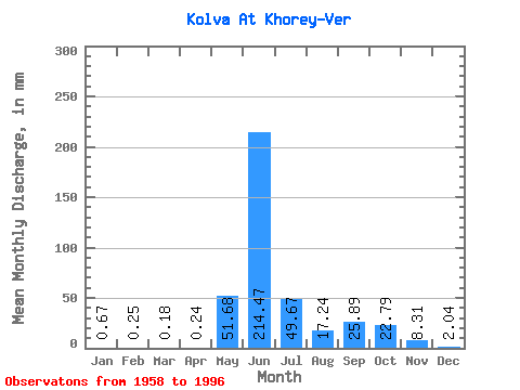
| Statistic | Jan | Feb | Mar | Apr | May | Jun | Jul | Aug | Sep | Oct | Nov | Dec | Annual |
|---|---|---|---|---|---|---|---|---|---|---|---|---|---|
| Mean | 0.67 | 0.26 | 0.18 | 0.23 | 51.68 | 214.47 | 49.66 | 17.24 | 25.89 | 22.79 | 8.31 | 2.04 | 408.37 |
| Standard Deviation | 0.55 | 0.21 | 0.16 | 0.21 | 70.74 | 86.30 | 34.81 | 14.02 | 14.71 | 13.70 | 8.70 | 1.23 | 87.27 |
| Min | 0.06 | 0.01 | 0.00 | 0.01 | 0.08 | 85.29 | 14.64 | 3.98 | 2.98 | 2.16 | 0.73 | 0.10 | 241.20 |
| Max | 2.06 | 0.82 | 0.60 | 0.75 | 221.78 | 450.64 | 198.28 | 73.44 | 60.65 | 63.65 | 41.13 | 4.95 | 614.90 |
| Coefficient of Variation | 0.82 | 0.80 | 0.88 | 0.91 | 1.37 | 0.40 | 0.70 | 0.81 | 0.57 | 0.60 | 1.05 | 0.60 | 0.21 |
 Return to R-Arctic Net Home Page