|
|
|||||||||||||||||
| Point ID: 7506 | Downloads | Plots | Site Data | Code: 70499 |
|
|
|||||||||||||||||
| Download | |
|---|---|
| Site Descriptor Information | Site Time Series Data |
| Link to all available data | |
| View: | Time Series | All |
| Units: | mm |
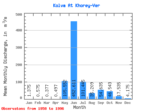
| Statistic | Jan | Feb | Mar | Apr | May | Jun | Jul | Aug | Sep | Oct | Nov | Dec | Annual |
|---|---|---|---|---|---|---|---|---|---|---|---|---|---|
| Mean | 1.38 | 0.57 | 0.38 | 0.50 | 105.55 | 452.61 | 101.44 | 35.21 | 54.63 | 46.54 | 17.54 | 4.17 | 70.78 |
| Standard Deviation | 1.13 | 0.46 | 0.33 | 0.45 | 144.48 | 182.13 | 71.10 | 28.64 | 31.04 | 27.98 | 18.36 | 2.51 | 15.13 |
| Min | 0.13 | 0.01 | 0.01 | 0.02 | 0.17 | 180.00 | 29.90 | 8.14 | 6.29 | 4.41 | 1.54 | 0.20 | 41.80 |
| Max | 4.21 | 1.83 | 1.22 | 1.59 | 453.00 | 951.00 | 405.00 | 150.00 | 128.00 | 130.00 | 86.80 | 10.10 | 106.57 |
| Coefficient of Variation | 0.82 | 0.80 | 0.88 | 0.91 | 1.37 | 0.40 | 0.70 | 0.81 | 0.57 | 0.60 | 1.05 | 0.60 | 0.21 |
 Return to R-Arctic Net Home Page