|
|
|||||||||||||||||
| Point ID: 7505 | Downloads | Plots | Site Data | Code: 70498 |
|
|
|||||||||||||||||
| Download | |
|---|---|
| Site Descriptor Information | Site Time Series Data |
| Link to all available data | |
| View: | Time Series | All |
| Units: | m3/s |
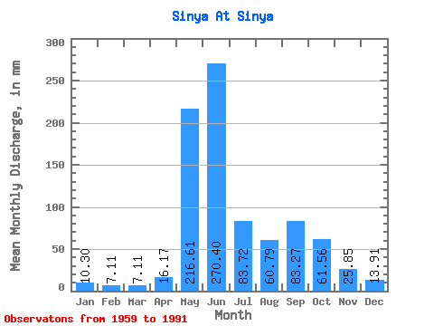
| Statistic | Jan | Feb | Mar | Apr | May | Jun | Jul | Aug | Sep | Oct | Nov | Dec | Annual |
|---|---|---|---|---|---|---|---|---|---|---|---|---|---|
| Mean | 10.30 | 7.17 | 7.11 | 16.18 | 216.57 | 270.40 | 83.71 | 60.78 | 83.27 | 61.55 | 25.85 | 13.91 | 861.87 |
| Standard Deviation | 1.65 | 1.03 | 1.35 | 20.75 | 116.90 | 111.76 | 38.48 | 41.76 | 43.30 | 31.51 | 15.91 | 2.77 | 163.25 |
| Min | 6.37 | 5.19 | 3.55 | 5.01 | 12.34 | 91.11 | 29.21 | 16.80 | 20.62 | 21.10 | 8.74 | 9.15 | 540.25 |
| Max | 12.86 | 9.61 | 10.55 | 102.70 | 428.07 | 534.11 | 177.93 | 162.10 | 180.66 | 147.90 | 89.94 | 19.96 | 1158.87 |
| Coefficient of Variation | 0.16 | 0.14 | 0.19 | 1.28 | 0.54 | 0.41 | 0.46 | 0.69 | 0.52 | 0.51 | 0.62 | 0.20 | 0.19 |
 Return to R-Arctic Net Home Page