|
|
|||||||||||||||||
| Point ID: 7505 | Downloads | Plots | Site Data | Code: 70498 |
|
|
|||||||||||||||||
| Download | |
|---|---|
| Site Descriptor Information | Site Time Series Data |
| Link to all available data | |
| View: | Time Series | All |
| Units: | mm |
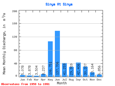
| Statistic | Jan | Feb | Mar | Apr | May | Jun | Jul | Aug | Sep | Oct | Nov | Dec | Annual |
|---|---|---|---|---|---|---|---|---|---|---|---|---|---|
| Mean | 5.08 | 3.88 | 3.50 | 8.24 | 106.75 | 137.71 | 41.26 | 29.96 | 42.41 | 30.34 | 13.16 | 6.86 | 36.05 |
| Standard Deviation | 0.81 | 0.56 | 0.66 | 10.56 | 57.62 | 56.91 | 18.97 | 20.58 | 22.05 | 15.53 | 8.10 | 1.36 | 6.83 |
| Min | 3.14 | 2.81 | 1.75 | 2.55 | 6.08 | 46.40 | 14.40 | 8.28 | 10.50 | 10.40 | 4.45 | 4.51 | 22.60 |
| Max | 6.34 | 5.20 | 5.20 | 52.30 | 211.00 | 272.00 | 87.70 | 79.90 | 92.00 | 72.90 | 45.80 | 9.84 | 48.47 |
| Coefficient of Variation | 0.16 | 0.14 | 0.19 | 1.28 | 0.54 | 0.41 | 0.46 | 0.69 | 0.52 | 0.51 | 0.62 | 0.20 | 0.19 |
 Return to R-Arctic Net Home Page