|
|
|||||||||||||||||
| Point ID: 7504 | Downloads | Plots | Site Data | Code: 70497 |
|
|
|||||||||||||||||
| Download | |
|---|---|
| Site Descriptor Information | Site Time Series Data |
| Link to all available data | |
| View: | Time Series | All |
| Units: | m3/s |
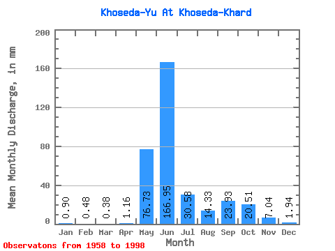
| Statistic | Jan | Feb | Mar | Apr | May | Jun | Jul | Aug | Sep | Oct | Nov | Dec | Annual |
|---|---|---|---|---|---|---|---|---|---|---|---|---|---|
| Mean | 0.90 | 0.48 | 0.38 | 1.16 | 76.72 | 166.95 | 30.57 | 14.33 | 23.93 | 20.50 | 7.04 | 1.94 | 374.99 |
| Standard Deviation | 0.64 | 0.37 | 0.37 | 1.69 | 75.23 | 78.79 | 23.48 | 14.11 | 16.05 | 13.18 | 8.00 | 1.30 | 66.66 |
| Min | 0.05 | 0.00 | 0.00 | 0.04 | 0.01 | 55.48 | 7.13 | 2.42 | 1.93 | 3.11 | 1.26 | 0.16 | 288.23 |
| Max | 2.25 | 1.39 | 1.34 | 5.06 | 218.47 | 334.23 | 105.24 | 67.77 | 63.89 | 64.95 | 43.20 | 5.44 | 542.25 |
| Coefficient of Variation | 0.71 | 0.76 | 0.99 | 1.45 | 0.98 | 0.47 | 0.77 | 0.98 | 0.67 | 0.64 | 1.14 | 0.67 | 0.18 |
 Return to R-Arctic Net Home Page