|
|
|||||||||||||||||
| Point ID: 7504 | Downloads | Plots | Site Data | Code: 70497 |
|
|
|||||||||||||||||
| Download | |
|---|---|
| Site Descriptor Information | Site Time Series Data |
| Link to all available data | |
| View: | Time Series | All |
| Units: | mm |
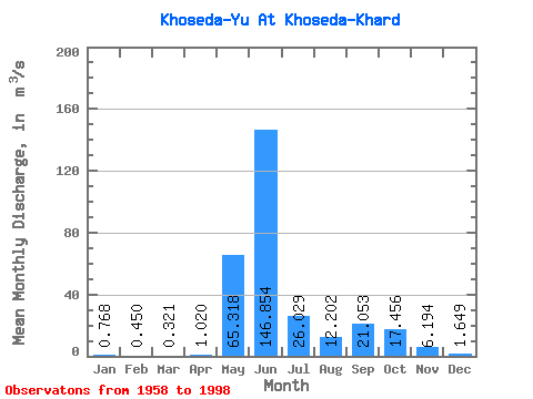
| Statistic | Jan | Feb | Mar | Apr | May | Jun | Jul | Aug | Sep | Oct | Nov | Dec | Annual |
|---|---|---|---|---|---|---|---|---|---|---|---|---|---|
| Mean | 0.77 | 0.45 | 0.32 | 1.02 | 65.32 | 146.85 | 26.03 | 12.20 | 21.05 | 17.46 | 6.19 | 1.65 | 27.09 |
| Standard Deviation | 0.54 | 0.34 | 0.32 | 1.48 | 64.05 | 69.30 | 19.99 | 12.01 | 14.11 | 11.22 | 7.04 | 1.11 | 4.82 |
| Min | 0.05 | 0.00 | 0.00 | 0.04 | 0.01 | 48.80 | 6.07 | 2.06 | 1.70 | 2.65 | 1.11 | 0.14 | 20.82 |
| Max | 1.92 | 1.30 | 1.14 | 4.45 | 186.00 | 294.00 | 89.60 | 57.70 | 56.20 | 55.30 | 38.00 | 4.63 | 39.17 |
| Coefficient of Variation | 0.71 | 0.76 | 0.99 | 1.45 | 0.98 | 0.47 | 0.77 | 0.98 | 0.67 | 0.64 | 1.14 | 0.67 | 0.18 |
 Return to R-Arctic Net Home Page