|
|
|||||||||||||||||
| Point ID: 7502 | Downloads | Plots | Site Data | Code: 70494 |
|
|
|||||||||||||||||
| Download | |
|---|---|
| Site Descriptor Information | Site Time Series Data |
| Link to all available data | |
| View: | Time Series | All |
| Units: | m3/s |
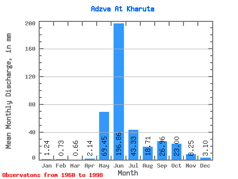
| Statistic | Jan | Feb | Mar | Apr | May | Jun | Jul | Aug | Sep | Oct | Nov | Dec | Annual |
|---|---|---|---|---|---|---|---|---|---|---|---|---|---|
| Mean | 1.24 | 0.74 | 0.66 | 2.14 | 69.44 | 196.86 | 43.32 | 18.71 | 26.96 | 23.00 | 8.25 | 3.10 | 398.70 |
| Standard Deviation | 0.53 | 0.34 | 0.28 | 6.36 | 75.12 | 82.76 | 25.48 | 13.29 | 15.93 | 12.96 | 6.89 | 3.40 | 71.81 |
| Min | 0.40 | 0.19 | 0.06 | 0.03 | 0.19 | 64.65 | 13.88 | 5.29 | 4.53 | 4.46 | 1.84 | 0.57 | 285.32 |
| Max | 2.78 | 1.76 | 1.33 | 39.62 | 241.33 | 342.62 | 139.75 | 67.10 | 64.35 | 71.41 | 33.37 | 21.42 | 577.44 |
| Coefficient of Variation | 0.43 | 0.46 | 0.43 | 2.97 | 1.08 | 0.42 | 0.59 | 0.71 | 0.59 | 0.56 | 0.83 | 1.09 | 0.18 |
 Return to R-Arctic Net Home Page