|
|
|||||||||||||||||
| Point ID: 7502 | Downloads | Plots | Site Data | Code: 70494 |
|
|
|||||||||||||||||
| Download | |
|---|---|
| Site Descriptor Information | Site Time Series Data |
| Link to all available data | |
| View: | Time Series | All |
| Units: | mm |
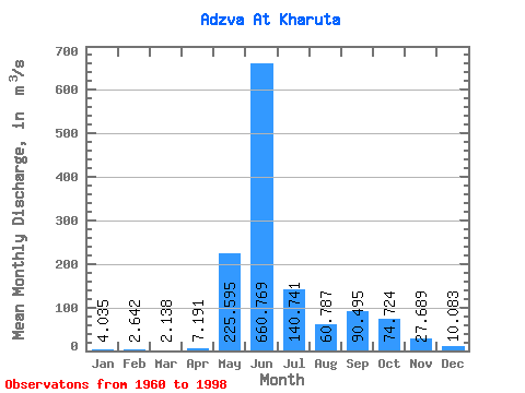
| Statistic | Jan | Feb | Mar | Apr | May | Jun | Jul | Aug | Sep | Oct | Nov | Dec | Annual |
|---|---|---|---|---|---|---|---|---|---|---|---|---|---|
| Mean | 4.04 | 2.64 | 2.14 | 7.19 | 225.59 | 660.77 | 140.74 | 60.79 | 90.50 | 74.72 | 27.69 | 10.08 | 109.91 |
| Standard Deviation | 1.73 | 1.23 | 0.91 | 21.36 | 244.04 | 277.77 | 82.78 | 43.17 | 53.46 | 42.12 | 23.11 | 11.03 | 19.80 |
| Min | 1.30 | 0.68 | 0.18 | 0.11 | 0.63 | 217.00 | 45.10 | 17.20 | 15.20 | 14.50 | 6.19 | 1.84 | 78.65 |
| Max | 9.04 | 6.27 | 4.32 | 133.00 | 784.00 | 1150.00 | 454.00 | 218.00 | 216.00 | 232.00 | 112.00 | 69.60 | 159.18 |
| Coefficient of Variation | 0.43 | 0.46 | 0.43 | 2.97 | 1.08 | 0.42 | 0.59 | 0.71 | 0.59 | 0.56 | 0.83 | 1.09 | 0.18 |
 Return to R-Arctic Net Home Page