|
|
|||||||||||||||||
| Point ID: 7500 | Downloads | Plots | Site Data | Code: 70487 |
|
|
|||||||||||||||||
| Download | |
|---|---|
| Site Descriptor Information | Site Time Series Data |
| Link to all available data | |
| View: | Time Series | All |
| Units: | m3/s |
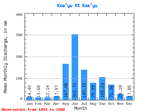
| Statistic | Jan | Feb | Mar | Apr | May | Jun | Jul | Aug | Sep | Oct | Nov | Dec | Annual |
|---|---|---|---|---|---|---|---|---|---|---|---|---|---|
| Mean | 14.39 | 11.78 | 12.14 | 17.97 | 167.03 | 302.71 | 140.13 | 79.98 | 105.21 | 71.35 | 28.18 | 17.84 | 952.02 |
| Standard Deviation | 7.33 | 7.06 | 7.16 | 17.58 | 85.20 | 90.39 | 60.81 | 38.46 | 48.34 | 41.33 | 15.02 | 7.71 | 137.09 |
| Min | 3.53 | 3.01 | 4.57 | 5.74 | 11.87 | 141.79 | 41.10 | 27.57 | 32.40 | 21.94 | 6.11 | 5.25 | 689.53 |
| Max | 43.75 | 42.04 | 42.56 | 103.94 | 373.20 | 520.33 | 306.91 | 180.30 | 204.02 | 239.30 | 89.18 | 45.41 | 1245.93 |
| Coefficient of Variation | 0.51 | 0.60 | 0.59 | 0.98 | 0.51 | 0.30 | 0.43 | 0.48 | 0.46 | 0.58 | 0.53 | 0.43 | 0.14 |
 Return to R-Arctic Net Home Page