|
|
|||||||||||||||||
| Point ID: 7500 | Downloads | Plots | Site Data | Code: 70487 |
|
|
|||||||||||||||||
| Download | |
|---|---|
| Site Descriptor Information | Site Time Series Data |
| Link to all available data | |
| View: | Time Series | All |
| Units: | mm |
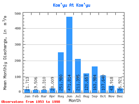
| Statistic | Jan | Feb | Mar | Apr | May | Jun | Jul | Aug | Sep | Oct | Nov | Dec | Annual |
|---|---|---|---|---|---|---|---|---|---|---|---|---|---|
| Mean | 21.71 | 19.51 | 18.31 | 28.01 | 251.98 | 471.81 | 211.40 | 120.66 | 163.98 | 107.64 | 43.92 | 26.92 | 121.87 |
| Standard Deviation | 11.05 | 11.69 | 10.80 | 27.40 | 128.53 | 140.89 | 91.73 | 58.02 | 75.34 | 62.35 | 23.41 | 11.63 | 17.55 |
| Min | 5.32 | 4.99 | 6.89 | 8.94 | 17.90 | 221.00 | 62.00 | 41.60 | 50.50 | 33.10 | 9.52 | 7.92 | 88.27 |
| Max | 66.00 | 69.60 | 64.20 | 162.00 | 563.00 | 811.00 | 463.00 | 272.00 | 318.00 | 361.00 | 139.00 | 68.50 | 159.49 |
| Coefficient of Variation | 0.51 | 0.60 | 0.59 | 0.98 | 0.51 | 0.30 | 0.43 | 0.48 | 0.46 | 0.58 | 0.53 | 0.43 | 0.14 |
 Return to R-Arctic Net Home Page