|
|
|||||||||||||||||
| Point ID: 7493 | Downloads | Plots | Site Data | Code: 70457 |
|
|
|||||||||||||||||
| Download | |
|---|---|
| Site Descriptor Information | Site Time Series Data |
| Link to all available data | |
| View: | Time Series | All |
| Units: | m3/s |
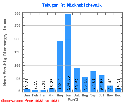
| Statistic | Jan | Feb | Mar | Apr | May | Jun | Jul | Aug | Sep | Oct | Nov | Dec | Annual |
|---|---|---|---|---|---|---|---|---|---|---|---|---|---|
| Mean | 10.21 | 7.21 | 7.01 | 15.25 | 192.18 | 294.05 | 90.96 | 56.19 | 77.61 | 62.52 | 24.42 | 14.30 | 854.87 |
| Standard Deviation | 3.02 | 1.80 | 1.59 | 17.22 | 96.65 | 100.66 | 39.55 | 27.01 | 31.34 | 27.38 | 10.47 | 4.54 | 135.62 |
| Min | 2.86 | 2.60 | 2.72 | 3.54 | 20.04 | 133.25 | 30.79 | 23.99 | 28.39 | 17.11 | 4.83 | 5.63 | 595.37 |
| Max | 19.23 | 11.46 | 10.89 | 81.81 | 380.50 | 522.90 | 248.34 | 140.87 | 190.60 | 129.54 | 55.10 | 27.56 | 1215.53 |
| Coefficient of Variation | 0.30 | 0.25 | 0.23 | 1.13 | 0.50 | 0.34 | 0.43 | 0.48 | 0.40 | 0.44 | 0.43 | 0.32 | 0.16 |
 Return to R-Arctic Net Home Page