|
|
|||||||||||||||||
| Point ID: 7493 | Downloads | Plots | Site Data | Code: 70457 |
|
|
|||||||||||||||||
| Download | |
|---|---|
| Site Descriptor Information | Site Time Series Data |
| Link to all available data | |
| View: | Time Series | All |
| Units: | mm |
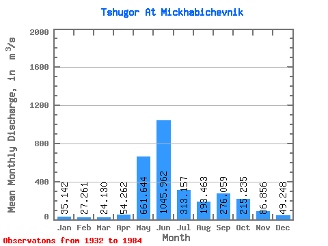
| Statistic | Jan | Feb | Mar | Apr | May | Jun | Jul | Aug | Sep | Oct | Nov | Dec | Annual |
|---|---|---|---|---|---|---|---|---|---|---|---|---|---|
| Mean | 35.14 | 27.26 | 24.13 | 54.26 | 661.64 | 1045.96 | 313.16 | 193.46 | 276.06 | 215.24 | 86.86 | 49.25 | 249.75 |
| Standard Deviation | 10.40 | 6.79 | 5.47 | 61.26 | 332.75 | 358.06 | 136.18 | 92.98 | 111.46 | 94.27 | 37.23 | 15.63 | 39.62 |
| Min | 9.86 | 9.82 | 9.37 | 12.60 | 69.00 | 474.00 | 106.00 | 82.60 | 101.00 | 58.90 | 17.20 | 19.40 | 173.93 |
| Max | 66.20 | 43.30 | 37.50 | 291.00 | 1310.00 | 1860.00 | 855.00 | 485.00 | 678.00 | 446.00 | 196.00 | 94.90 | 355.11 |
| Coefficient of Variation | 0.30 | 0.25 | 0.23 | 1.13 | 0.50 | 0.34 | 0.43 | 0.48 | 0.40 | 0.44 | 0.43 | 0.32 | 0.16 |
 Return to R-Arctic Net Home Page