|
|
|||||||||||||||||
| Point ID: 7474 | Downloads | Plots | Site Data | Code: 70396 |
|
|
|||||||||||||||||
| Download | |
|---|---|
| Site Descriptor Information | Site Time Series Data |
| Link to all available data | |
| View: | Time Series | All |
| Units: | m3/s |
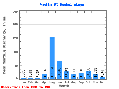
| Statistic | Jan | Feb | Mar | Apr | May | Jun | Jul | Aug | Sep | Oct | Nov | Dec | Annual |
|---|---|---|---|---|---|---|---|---|---|---|---|---|---|
| Mean | 5.05 | 3.68 | 3.75 | 15.12 | 122.76 | 54.46 | 23.57 | 14.66 | 19.18 | 24.98 | 16.35 | 8.34 | 309.61 |
| Standard Deviation | 1.42 | 1.03 | 0.82 | 21.32 | 38.77 | 30.34 | 12.67 | 12.07 | 14.03 | 13.57 | 8.67 | 3.18 | 57.54 |
| Min | 2.10 | 1.21 | 1.83 | 2.71 | 42.57 | 14.87 | 5.99 | 3.58 | 3.15 | 2.50 | 2.44 | 2.45 | 152.72 |
| Max | 8.43 | 6.45 | 5.43 | 107.64 | 198.74 | 150.06 | 58.49 | 73.15 | 93.04 | 69.91 | 47.20 | 17.20 | 440.44 |
| Coefficient of Variation | 0.28 | 0.28 | 0.22 | 1.41 | 0.32 | 0.56 | 0.54 | 0.82 | 0.73 | 0.54 | 0.53 | 0.38 | 0.19 |
 Return to R-Arctic Net Home Page